
As of 4:00 this afternoon, Tropical Depression 17-E has now been upgraded to a Tropical Storm and officially given the name “Rick.”
Hurricane and Tropical Storm watches have been issued for coastal areas of southwestern Mexico. They are not quite in our immediate area, but beware of possible conditions of excessive rain and flooding. Again.
A Hurricane Watch was issued from Zihuatanejo to Punta San Telmo. A Hurricane Watch means that hurricane conditions of winds over 74mph are possible within the watch area, and are issued an estimated 48 hours beforehand.
Tropical Storm Watches were issued for East of Zihuatanejo to Tecpan de Galeana, and West of Punta San Telmo to Manzanillo. A Tropical Storm Watch means that tropical storm conditions of winds between 39 and 73 mph are possible within the area indicated.
It is expected that the Watches will be upgraded to Hurricane and Tropical Storm Warnings tonight or tomorrow morning. The difference between Watch and Warning is really just a matter of time, a Watch indicates conditions are expected within 48 hours, and a Warning indicates conditions are expected within 24 hours.
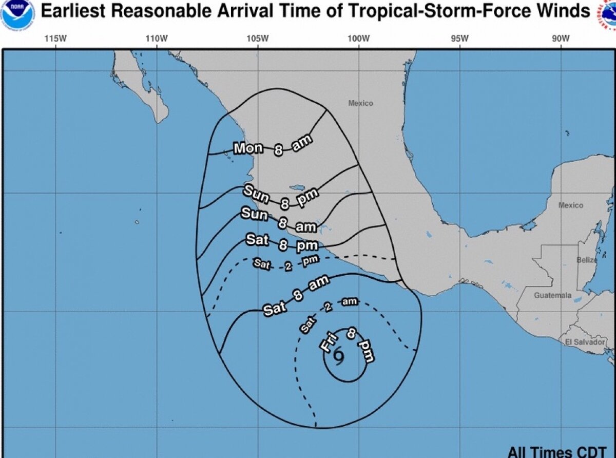
Currently “Rick” is located near latitude 13.1 north, 101.0 west, and is moving west-northwest at about 7 mph, with sustained winds around 40mph. “Rick” is expected to turn northwest tonight, and pick up strength with probable hurricane status by Saturday night, approaching landfall later this weekend or early next week. Storm-force winds are anticipated extending about 45 miles from the storm center. Tropical storm conditions are possible in watch areas by Sunday afternoon. Significant storm surge and coastal flooding are expected in the areas of landfall, with large and destructive waves, and strong rip currents as well.

“Rick” is estimated to deliver 5-10 inches of rainfall across the coastal areas of Guerrero, Michoacan, and Colima, likely producing flooding and mudslides.
Hurricanes are among nature's most powerful and destructive phenomena. In the Central Pacific Ocean, an average of 3 tropical storms, 2 of which become hurricanes form or move over the area during the hurricane season, which runs from June 1 to November 30 each year.
While hurricanes pose the greatest threat to life and property, tropical storms and depressions also can be devastating. The primary hazards from tropical cyclones (which include tropical depressions, tropical storms, and hurricanes) are storm surge flooding, inland flooding from heavy rains, destructive winds, sometimes tornadoes, and high surf and rip currents.
- Storm surge is the abnormal rise of water generated by a storm's winds. This hazard is historically the leading cause of hurricane related deaths. Storm surge and large battering waves can result in loss of life and cause massive destruction along the coast.
- Storm surge can travel several miles inland, especially along bays, rivers, and estuaries.
- Flooding from heavy rains is the second leading cause of fatalities from landfalling hurricanes and tropical storms. Widespread torrential rains associated with these storms often cause flooding hundreds of miles inland. This flooding can persist for several days after a storm has dissipated.
- Winds from a hurricane can destroy buildings and homes. Signs, roofing material, and any items left outside can become flying missiles during hurricanes.
- Tornadoes can accompany landfalling hurricanes and tropical storms. They typically occur in rain bands well away from the center of the storm.
- Dangerous waves produced by a hurricane or tropical storm's strong winds can pose a significant hazard to coastal residents and mariners. These waves can cause deadly rip currents, significant beach erosion, and damage to structures along the coastline, even possible when the storm is hundreds of miles offshore.
For the latest updates, visit the NOAA website:
https://www.nhc.noaa.gov/text/refresh/MIATCPEP2+shtml/221453.shtml